
 Español
  Deutsch
  Français
  Italiano
If you think that touring lunar landscapes between craters, dunes, cliffs and infinite beaches is your ideal plan, don’t delay any longer: put on your boots, it’s time to go hiking in Fuerteventura. The second largest island of the Canary archipelago, Fuerteventura is a true paradise of protected natural spaces and unique landscapes.
The desert area of the Jandía Natural Park brings together some of the most spectacular hiking trails on the island. As you pass through this place you will be able to admire ravines, impressive rock formations on the edge of the sea and bare slopes dotted with cardones de Jandía, one of the endemic species of Fuerteventura.
1. Pico de la Zarza
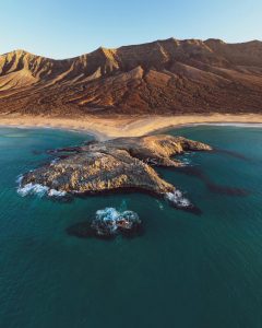
The PR 54 trail takes us for more than 7 kilometers to the top of the highest mountain in Fuerteventura. A route that starts from Morro Jable and ends at Pico de La Zarza at 807 meters above sea level. This route is not technically difficult for those who practice hiking in Fuerteventura, but it requires an extra expenditure of energy, since the whole path is uphill. Our effort will have a pleasant reward, enjoying wonderful views from the summit. From El Pico de La Zarza you can see the entire Cofete arch, and the two ravines that flank it and that will lead to the town of Morro Jable. These ravines are the Barranco de Vinamar and the Barranco del Valle de Butihondo
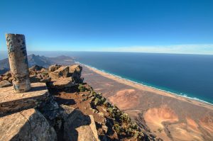
Difficulty: High
Kilometers: 7km
Time: 3h
Starting point: Morro Jable
2. Volcán Calderón Hondo
Spectacular circular that passes next to the Red Mountain and goes up to the crater of the Calderón Hondo Volcano. This is one of the 7 volcanoes that are part of the Bayuyo, whose eruption created the nearby Islote de Lobos.
As for the route, the trail is very easy and well signposted, so you will have no problem climbing its 278-meter height. From its 100 meter diameter crater you can admire the spectacular views of the north of Fuerteventura. The most frequented route is the one that starts in Lajares. At the entrance to Lajares, coming from Corralejo, at the roundabout we will take the first exit towards Majanicho. Just a kilometer later, when the buildings are finished, there is a small parking lot on the right. We can identify this place because there will be more cars parked and because of its information panel. There are few parking spaces, so we recommend getting up early. If there was no place to park, we would have to go back towards Lajares and find a space for our vehicle.
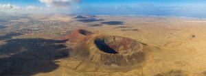
Difficulty: Low
Kilometers: 5km
Time: 1h 30min
Starting point: Lajares
3. Barranco de los Encantados
Also known as the Barranco de los Encantados, this route consists of following a path that reaches some impressive fossilized sand dunes. The great attraction is to see the curious shapes that its caves and walls full of marine fossils take.
The first part of the route is nothing special, but once you start to see these fossils it’s time to discover the best places to photograph. And if you go around the area you will find many more hills of this type. Undoubtedly, a perfect combination of ocean and mountain which occurred thousands of years ago when the sea bathed this region.
Difficulty: Low
Kilometers: 4km
Time: 1h
Starting point: End of the dirt road towards the ravine of the enchanted
4. Caldera de Gairía
Just a few kilometers from Tiscamanita is the path to climb another of the volcanoes of the Majorera island, the Caldera de Gairía. The crater of this Natural Monument reaches an altitude of 461 meters and from it you can see the rest of the volcanic cones in this area: Malpaís Grande or the Calderas de la Laguna, los Arrabales and de Liria.
Also, if you want to continue walking you can continue the path to any of them, always respecting the routes enabled for it.
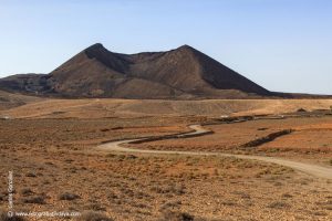
Difficulty: Low
Kilometers: 2.5km
Time: 1h
Starting point:Camino los Areneros in Tiscamanita.
5. Playa de Cofete y Playa de Barlovento
Wild and natural, Cofete beach is one of the treasures of southern Fuerteventura. At the foot of the highest mountains in Fuerteventura such as Pico de la Zarza, its 12-kilometre length is a paradise for walking by the sea. In fact, from the town of Cofete you can take a walk to either side:
1.To the left you will reach the Roque del Moro.
2.To the right is the Islet of Cofete, also known as the Islet of the Seven Widows.
Difficulty: Medium
Kilometers: 7km
Time: 3h
Starting point: Cofete Beach
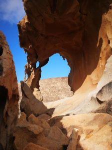
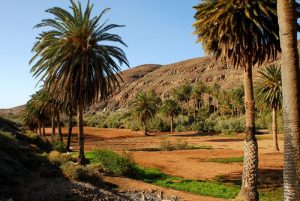
6. Barranco de las Peñitas
A paradise for climbers and geologists due to the plutonic rocks that form the landscape, the Barranco de las Peñitas Route is a true spectacle. In fact, it has been the setting for filming such well-known films as Marvel’s The Eternals or Exodus: Gods and Kings.
In addition to the landscape itself, which is totally worth it, during the trekking through this Majorero canyon you will be able to see the Palmeral de las Peñitas in the middle of these desert lands, one of the few dams in Fuerteventura or the popular Arco de las Peñitas.
Difficulty: Medium
Kilometers: 5km
Time: 2h
Starting point: Palmeral de las Peñitas
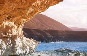
7. Cuevas de Ajuy
The Ajuy Natural Monument is located on the west coast of Fuerteventura, and is included in the Betancuria Rural Park, another of the Protected Natural Areas of Fuerteventura. The greatest interest in this natural area lies in the fact that it is made up of the oldest rocks in the entire Canary Islands, the so-called Basal Complex, made up of sedimentary, igneous and volcanic materials that tell us about the origin and formation of Fuerteventura more than 70 million years ago. years. The small town of Ajuy, located in Puerto de la Peña, is a small town next to a black sand beach, visited mainly by locals. As a curiosity we will say that this beach is the area chosen by Jean de Bethencourt, in 1402, to invade and conquer the island of Fuerteventura.
Difficulty: Low
Kilometers: 5km
Time: 1h 30 min.
Starting point: Arco del Jurado
8. El Cardón – El Tanquito
From the town of El Cardón begins a route that is divided into two sections:
Ermita del Tanquito: the first part is very easy and reaches this sanctuary located in a beautiful stone temple. The pilgrimage that is celebrated in honor of this virgin is very popular and covers precisely this same route.
Montaña El Cardón Natural Monument: from here begins an ascent to the 690-meter altitude of the hill to enjoy impressive views of the region. However, this second part is much more complicated since you have to go up a steep slope without signs.
If you have doubts about whether to complete it, you can go to the Hermitage and right there decide whether to continue or return.
Difficulty: Low
Kilometers: 4.5km
Time: 2h
Starting point: El Cardón
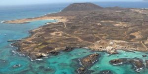
9. Circular de Isla de Lobos
This paradisiacal desert islet of Fuerteventura is famous for its impressive beaches with turquoise waters. However, the most adventurous will be able to fully explore the island with a simple but demanding circular ride. During the walk you will be able to climb the 127 meters of the Caldera Mountain to enjoy the panoramic views with Lobos, Fuerteventura and Lanzarote. Since 1992, the Islote de Lobos Natural Park has been proclaimed and the entire island is protected. Its ecological richness is overwhelming as it is home to more than 130 plant species and various bird species. It is also a submarine reserve area due to its fantastic sea beds.
Difficulty: Low
Kilometers: 8km
Time: 3h
Starting point: Puerto Isla de Lobos

